Indiana's Ports
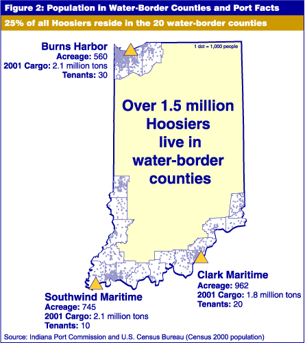
How many of us know that more than 400 miles of the state's border is water? This means that more than 50 percent of the Indiana border is water-based. This includes Lake Michigan and the Ohio and Wabash rivers. The three ports in Indiana are located in Portage, Jeffersonville and Mount Vernon.
According to the Indiana Port Commission, more than 6 million tons of cargo were shipped via these ports in 2001. A recent study estimated the economic impact value of that cargo to the state of Indiana was $1.5 billion in 1999. That study, by the Center for Urban Policy and the Environment at Indiana University, further estimated that the ports contributed $398 million in wages for Indiana workers; 10,503 direct and indirect jobs, $22 million in tax revenue for the state of Indiana, nearly $1.4 million in local property taxes and an additional $54 million of economic impact attributable to publicly funded construction projects completed in 1999.
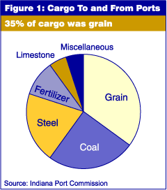
Most of the cargo is sent by barge, with only 25 percent going by ship, with a relatively even balance between outbound (55 percent) and inbound (45 percent) cargo. The largest of the three ports, Clark Maritime in Jeffersonville, is nearly 1,000 acres, shipping 1.8 million tons of cargo. Southwind Maritime has approximately 750 acres of port space and shipped 2.1 million tons of cargo in 2001. In one of the most densely populated areas of the state, Burns Harbor is 560 acres, almost half the size of its southern sister in Jeffersonville, but shipped 2.1 million tons of cargo in 2001.
Carol O. Rogers
Associate Director, Indiana Business Research Center,
Kelley School of Business, Indiana University