Narrowing the focus: How the federal government plans to define metropolitan areas in the 2020s
Update (7/16/2021): The OMB has rejected the recommendation to double the population threshold to qualify as a metropolitan statistical area. It will remain at 50,000.

Bartholomew County's historic courthouse is in Columbus, Indiana. Columbus is one of five MSAs in the state that could lose its metropolitan status under the proposed guidelines.
Metros, micros, metropolitan areas, metropolitan statistical areas—for anyone who uses federal data, these words mean something. They tell us about a geography that is not political or municipal, as opposed to cities and towns, counties, or even townships.
Metropolitan statistical areas are a geographic concept, a standardized way of organizing groups of counties that was first developed back in the late 1940s to help federal government with a so-called “single set of geographic delineations for the nation’s largest centers of population and activity.”1 Even earlier than that, the U.S. Census Bureau had come up with what they termed industrial districts, for the Census of Manufactures and used a metropolitan district formulation that grouped together townships (otherwise known as minor civil divisions).
These delineations have come a long way from the relatively sparse number of Standard Metropolitan Statistical Areas (SMSAs), which is what they were called until 1983, when the word Standard was dropped. By 2003, when Mitch Daniels, then-director of the Office of Management and Budget (OMB) who later became Indiana's governor, released the definitions, there was a new nomenclature—core-based statistical areas, which denote both MSAs and micropolitan statistical areas (micros). It also delineated combined statistical areas (CSAs), which combine two or more core-based statistical areas into what can generally be thought of as a “super metro.” Figure 1 shows the configuration of the three types of areas for Indiana.
Figure 1: Indiana’s statistical areas
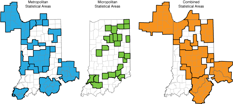
Note: These maps show the April 2018 vintage of the metros because the September 2018 vintage (minor changes) are not yet reflected in the data released by the U.S. Bureau of Labor Statistics.
Source: Indiana Business Research Center
Proposed changes
On Jan. 19, 2021, a notice was filed in the Federal Register to request public comment on the proposed changes to these geographic standards by the Metropolitan and Micropolitan Statistical Area Standards Review Committee, chaired by James D. Fitzsimmons. We want to alert Hoosiers to these proposed changes to redefine these metropolitan areas—which may reduce the number of MSAs we have in Indiana. These definitions can impact how Indiana is “seen” by site selectors, businesses, the media and the economic development community writ large.
Currently, Indiana has 12 metropolitan areas where the core county is in Indiana; an additional three metro areas have an out-of-state core county but include one or more Indiana counties. We also have 24 micropolitan areas, which are distinguished by having a core city with a population of at least 10,000 but less than 50,000. And finally, we have seven combined (super) metro areas within Indiana and have Indiana counties that are part of an additional three combined metros (Chicago, Louisville and Cincinnati) in contiguous states.
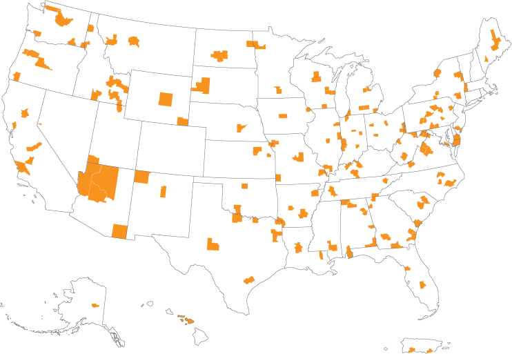
The new recommendations call for metropolitan areas to have an urbanized core with a population of at least 100,000, in part because the core size of 50,000 hasn’t been changed since the 1950s. The net effect of this in Indiana (and much of the Midwest) would mean that five current MSAs—Michigan City-La Porte, Kokomo, Muncie, Terre Haute and Columbus—could be demoted, if you will, to micropolitan status. This will depend on results from the 2020 Census, of course, but Figure 2 shows the urbanized areas in Indiana (and across the country) potentially impacted based on the last census in 2010.
Figure 2: Metropolitan statistical areas with an urbanized core of less than 100,000
Download larger pdf map with MSA names
Note: This map uses the September 2018 vintage of the statistical area delineations. Population is based on Census 2010.
Source: U.S. Census Bureau
There are six key recommendations the committee has put forward to OMB. The big deal here is increasing the population threshold for MSAs to a starting point of 100,000 population.
-
The minimum urban area population to qualify a metropolitan statistical area should be increased from 50,000 to 100,000.
-
The delineation of New England city and town areas (NECTAs), NECTA divisions, and combined NECTAs should be discontinued.
-
Research should be undertaken on an additional, territorially exhaustive classification that covers all of the United States and Puerto Rico.
-
The first annual delineation update of the coming decade should be combined with the decennial-based delineations.
-
OMB should make publicly available a schedule for updates to the core based statistical areas.
-
OMB should continue use of American Community Survey commuting data in measurement of intercounty connectivity, though changing societal and economic trends may warrant considering changes in the 2030 standards.
While this may seem a somewhat arcane regulation, it can impact how Indiana is seen across the country. We encourage our readers who have an interest, nay a vested interest, in how their communities are shown through the data provided by the federal government to read the notice and submit your comments.
References
-
Federal Register notice: “Recommendations from the Metropolitan and Micropolitan Statistical Area Standards Review Committee to the Office of Management and Budget concerning changes to the 2010 standards for delineating metropolitan and micropolitan statistical areas”
- Census Bureau history of metropolitan districts
Notes
- “Recommendations from the Metropolitan and Micropolitan Statistical Area Standards Review Committee to the Office of Management and Budget concerning changes to the 2010 standards for delineating metropolitan and micropolitan statistical areas,” Federal Register Notice 86 FR 5263, pages 5263-5266, document number 2021-00988, www.federalregister.gov/documents/2021/01/19/2021-00988/recommendations-from-the-metropolitan-and-micropolitan-statistical-area-standards-review-committee