The 2013 Metro Landscape for Indiana
The first statistical grouping of counties was defined in 1950 in an effort to create comparable data across similarly populated areas throughout the nation. At that time, Indiana had eight standard metropolitan statistical areas (SMSAs) where at least one county in the SMSA was within the state’s boundaries. In the 63 years since the original groupings, Indiana’s population has grown and become increasingly concentrated, leaving us with 15 metro areas and 24 micro areas in 2013.
According to the most recent data available, 77.5 percent of Indiana’s population lived in a metro while micros were 15.5 percent of the population in 2012. This means that only 7.1 percent of Indiana’s population is not part of a statistical area.1
Fifteen Metropolitan Areas
Metropolitan statistical areas are defined as including a core county with a population of at least 50,000 and any adjacent counties that are highly integrated socially or economically. County integration is determined by commuting ties.
Twelve metros have the core county in Indiana (the county with a population of at least 50,000), while three metros have an out-of-state core county but include Indiana counties (see Figure 1).
Figure 1: Indiana's Metropolitan Statistical Areas, 2013
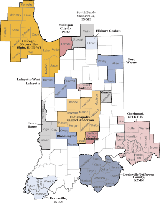
Note: The four Indiana counties in the Chicago metro area form the Gary Metropolitan Division.
Source: Indiana Business Research Center, using February 2013 definitions from the OMB
The Chicago-Naperville-Elgin metro is the largest metro with counties in Indiana, but most of its large population lives outside of Indiana (nearly 8.8 million of 9.5 million people). If we look solely at the metros contained in Indiana, the Indianapolis-Carmel-Anderson metro is unsurprisingly the largest (see Table 1).
Table 1: Indiana Metro Population, 2000 to 2010
| Metropolitan Areas | Population | Change, 2000 to 2010 | |||
|---|---|---|---|---|---|
| Name | State(s) | April 1, 2000 | April 1, 2010 | Number | Percent |
| Chicago-Naperville-Elgin* | IL-IN-WI | 9,098,316 | 9,461,105 | 362,789 | 4.0 |
| Cincinnati* | OH-KY-IN | 1,994,830 | 2,114,580 | 119,750 | 6.0 |
| Indianapolis-Carmel-Anderson | IN | 1,658,462 | 1,887,877 | 229,415 | 13.8 |
| Louisville/Jefferson County* | KY-IN | 1,121,109 | 1,235,708 | 114,599 | 10.2 |
| Fort Wayne | IN | 390,156 | 416,257 | 26,101 | 6.7 |
| South Bend-Mishawaka* | IN-MI | 316,663 | 319,224 | 2,561 | 0.8 |
| Evansville* | IN-KY | 296,195 | 311,552 | 15,357 | 5.2 |
| Lafayette-West Lafayette | IN | 178,541 | 201,789 | 23,248 | 13.0 |
| Elkhart-Goshen | IN | 182,791 | 197,559 | 14,768 | 8.1 |
| Terre Haute | IN | 170,943 | 172,425 | 1,482 | 0.9 |
| Bloomington | IN | 142,349 | 159,549 | 17,200 | 12.1 |
| Muncie | IN | 118,769 | 117,671 | -1,098 | -0.9 |
| Michigan City-La Porte | IN | 110,106 | 111,467 | 1,361 | 1.2 |
| Kokomo | IN | 84,964 | 82,752 | -2,212 | -2.6 |
| Columbus | IN | 71,435 | 76,794 | 5,359 | 7.5 |
*Metros with at least one county outside Indiana's boundaries
Source: Indiana Business Research Center, using Census Bureau data
Twenty-Four Micropolitan Areas
Micropolitan statistical areas are counties with a population of at least 10,000 but less than 50,000 and any adjacent counties integrated by commuting. In Indiana, the only difference between the 2009 metro definitions and the 2013 metro definitions is that Scott County is no longer a micro (because it is now included in the Louisville/Jefferson County metro delineation). The other 24 micros are the same in 2013 as they were in 2003, the last time the definitions received major revisions (see Figure 2).
Figure 2: Indiana's Micropolitan Statistical Areas, 2013
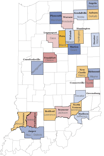
Source: Indiana Business Research Center, using February 2013 definitions from the OMB
One Metropolitan Division
In 2000, the term "Metropolitan Division" was introduced to divide metros that have a population core of at least 2.5 million.
There is one metropolitan division in Indiana—the Gary metro division, which includes Jasper, Lake, Newton, and Porter counties in the northwest corner of Indiana. It is a division of the Chicago-Naperville-Elgin metro and contains slightly more than 700,000 people.
Ten Combined Statistical Areas
There were eight combined statistical areas (CSAs) in Indiana with the 2009 definitions, but 10 with the new 2013 definitions (see Figure 3). CSAs are just what the name implies: metros and micros that are combined into a single region. How does the Office of Management and Budget (OMB) determine which counties make up a CSA? The answer is by looking at broader social and economic interactions (wholesaling, commodity distribution and weekend recreation activities). CSAs are defined to serve as a useful data set for regional authorities and the private sector, as they are the broader areas that give a better understanding of the overall demographics in an economically and socially connected area.
Figure 3: Indiana's Combined Statistical Areas, 2013
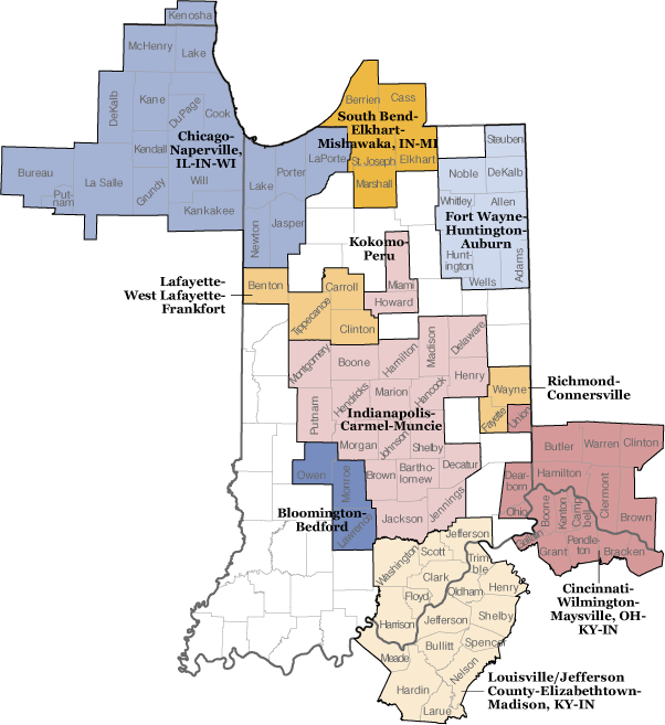
Source: Indiana Business Research Center, using February 2013 definitions from the OMB
It is important to note that the OMB changed its standards and how they apply to the Census Bureau data, which resulted in more CSAs across the United States, not only in Indiana.
Comparing Apples to Apples
We know that comparing micros to micros and metros to metros is acceptable, but what about the trickier ones, like metros to metro divisions? Because the criteria used to determine the boundaries are different for metros and metro divisions, the OMB does not generally suggest ranking or directly comparing metros to metro divisions. However, since the divisions contain such large populations and often have similar patterns as metros, there are cases when using the metro division in comparison to metros is acceptable. For example, the Gary metro division is often compared to other metros in Indiana since it is such a small component of the larger Chicago region and its population is entirely contained in Indiana.
On the other hand, one should not compare CSAs to individual metros and micros because CSAs are groupings of metros and micros, which makes them incompatible for comparison.
How the New 2013 Definitions Affect Hoosiers
Metros change over time. For example, the Anderson metro is no longer a single-county metro. It has amalgamated with the Indianapolis-Carmel-Anderson delineation, indicating Madison County’s close commuting ties with the Indianapolis area.
Five Indiana counties were either completely dropped or added from the metro/micro lists from 2009 to 2013 (see Table 2). Four of the five counties were dropped from metros. Union County was the only county added to a metro that was not included in the 2009 delineations.
Table 2: Counties Added or Dropped from Statistical Area Delineations, 2009 to 2013
| County | Added to the 2013 Definition | Dropped from the 2013 Definition |
|---|---|---|
| Franklin | Cincinnati, OH-KY-IN Metro | |
| Gibson | Evansville, IN-KY Metro | |
| Greene | Bloomington Metro | |
| Tipton | Kokomo Metro | |
| Union | Cincinnati, OH-KY-IN Metro |
Source: Indiana Business Research Center
What does this mean for the areas now included and those counties that were dropped from the groupings? While the OMB advises against using these data specifically for nonstatistical purposes (i.e., funding and grants), the data are often used either directly or indirectly to determine funding for certain programs. Therefore, the counties now included in definitions may see access to certain program funds that were not previously available and vice versa.
Metros, micros and CSAs are not urban and rural classifications. The OMB states that the delineations it uses may contain both urban and rural settings and to refer to them as one or the other would be misleading. Therefore, if certain programs plan on using these data for funding based on urban and rural definitions, planners should look more closely in each area to determine whether or not to include specific counties or areas and not necessarily use the pre-defined statistical areas.
Learn More
For more on the OMB’s standards, see 2010 Standards for Delineating Metropolitan and Micropolitan Statistical Areas.
For a complete list of the nation’s metros, micros and CSAs, see Revised Delineations of Metropolitan Statistical Areas, Micropolitan Statistical Areas, and Combined Statistical Areas, and Guidance on Uses of the Delineations of These Areas.