Measuring Rurality
Rurality is a vague concept. Being rural as opposed to urban is an attribute that people easily attach to a place based on their own perceptions, which may include low population density, abundance of farmland or remoteness from urban areas.
In contrast to this colloquial use, there is no consensus among researchers about how to define or measure the concept of rurality. Many existing measures are ill suited, if not flawed—including the commonly used metropolitan/nonmetropolitan definitions from the federal Office of Management and Budget (OMB). (1) Many counties with low population size and low density are allocated to the same category as highly urban counties; a prime example is the inclusion of both Brown County and Marion County in the Indianapolis–Carmel metro area. Likewise, the urban influence code defined by the U.S. Department of Agriculture's Economic Research Service does a good job in measuring accessibility to a metro area, but a poor job in capturing a county's rural character.
The Index of Relative Rurality
A recently introduced, continuous, multidimensional measure of rurality, the Index of Relative Rurality (IRR), avoids the confusing effects of inclusion in metro boundaries. (2) It does not answer the question “Is a county rural or urban?” but instead addresses the question “What is a county's degree of rurality?”
The IRR is based on four dimensions of rurality: population, population density, extent of urbanized area and distance to the nearest metro area. These dimensions are unquestioned in terms of their contribution to rurality and are incorporated implicitly in many existing rurality definitions. The index is scaled from 0 to 1, with 0 representing the most urban place and 1 representing the most rural place (see Figure 1).
Figure 1: U.S. Index of Relative Rurality, 2000
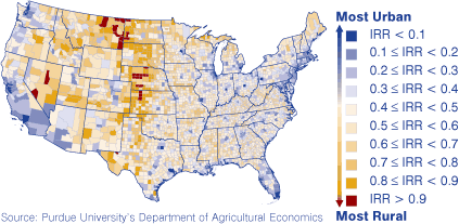
The lowest rurality scores (i.e., highly urban areas) are recorded for counties along the coasts as well as for the urban centers along the Great Lakes. Counties east of the Mississippi have low to medium levels of rurality; the most rural county east of the Mississippi is Keweenaw, Mich., with an IRR value of 0.895. Moving west from the Midwest to the Great Plains coincides with a distinct increase in rurality. In fact, extreme rurality (IRR > 0.8) is widely prevalent in many counties of the Great Plains and the Mountain States.
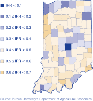
Within Indiana, IRRs ranged from 0.09 in Marion County to 0.64 in Crawford County (see Figure 2).
Figure 2: Indiana's Index of Relative Rurality, 2000
Defining the Rural-Metropolitan Interface
Rurality plays out differently for counties within the influence of a metropolitan area versus places that are far away from a metropolitan area. The most obvious reason for this difference is accessibility to the amenities of a metro area, such as airports, shopping and cultural opportunities.
The IRR can capture the rurality of a place based on a set of widely accepted characteristics (small size, low density, remoteness) but—because of the index's composite nature—cannot be used to pinpoint the county's location relative to a metro area. (3) Coupling the IRR with the urban influence code captures the idea of a rural-metropolitan interface, as they are responsive to both rurality and metro-accessibility.
The result is seven levels that are jointly defined by rurality and metropolitan access (see Table 1).
Table 1: Definitions of the Rural-Metropolitan Interface Levels
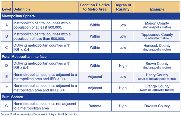
- Levels A and B refer to highly urban metropolitan core counties. They differ by population size (above vs. below 500,000).
- Levels C and D are outlying metropolitan counties. They differ by degree of rurality (IRR above vs. below 0.4).
- Levels E and F are nonmetropolitan counties adjacent to a metropolitan area. They, too, differ by the degree of rurality (above vs. below 0.4).
- Finally, level G includes nonmetropolitan counties that are not adjacent to a metropolitan area.
It is in levels D, E and F where the metropolitan sphere meets the rural sphere. These three levels are considered the rural-metropolitan interface.
Figure 3 shows the spatial distribution of the seven rural-metropolitan levels. Three features are most notable:
Figure 3: Rural-Metropolitan Levels, 2000
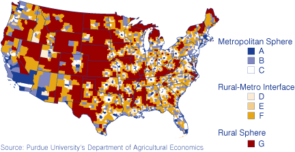
- There is an abundance of metropolitan counties along the coasts and the Great Lakes.
- The counties of the rural-metropolitan interface (levels D, E and F) form rings around the highly urban core of the metropolitan areas.
- In the western part of the United States, the rural-metropolitan interface consists primarily of level F counties. These are counties that are rural in character and adjacent to metropolitan core counties. A reason for the absence of level D and level E counties is undoubtedly the large size of counties that are often big enough to encompass a good deal of the urban sprawl.
On average, both the rurality (IRR) and the distance to the metropolitan center increase as we proceed from level A to level G (see Table 2). Only the 400 counties of level D deviate from this trend and deserve particular attention. These counties are part of metropolitan areas but are very rural in character. In fact, they are typically more rural than the 108 counties of level E that are adjacent but not within a metro area.
Table 2: Rural-Metropolitan Level by Population Share, Population Growth, Index of Relative Rurality and Distance to Metropolitan Center
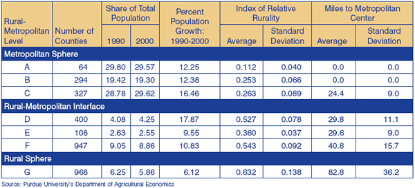
Level D counties also have the fastest population growth, amounting to 17.9 percent between 1990 and 2000 compared to only 13.1 percent for the entire population in the 3,108 counties of the continental United States. As a result, they slightly increased their share of the total population. In contrast, counties outside metropolitan areas (levels E, F and G) had a below-average population growth and thus a dwindling population share during the 1990s.
Indiana has 24 counties in the metro sphere and seven counties in the rural sphere, which means that the bulk of Hoosier counties (61) fall within the rural-metro interface.
Recognizing the important link between rurality and public policy, the Indiana Office of Community and Rural Affairs has developed a statewide strategic plan to help rural Indiana prosper. (4) Helping these counties in the rural-metro interface and the rural sphere succeed in an era of increasing urbanization and global competition will be a key factor in Indiana's future economic vitality.
Sidebar—Unlocking Rural Competitiveness: The Role of Regional Clusters
Recognizing both the challenges and opportunities facing rural America, the U.S. Economic Development Administration (EDA) chose to follow-up on a 2004 study (Competitiveness in Rural U.S. Regions: Learning and Research Agenda). One of the two consortia funded by the EDA for this work was a partnership among the Purdue University Center for Regional Development, the Indiana Business Research Center at Indiana University's Kelley School of Business, Strategic Development Group, Inc. and the State of Indiana.
The overall purpose of this new study was to develop a database and methodology to help rural areas in the United States assess their regional economic competitiveness to support growth and development strategies.
This article overviews a new way to measure rurality, which was used extensively in the study. To read the full report, Unlocking Rural Competitiveness: The Role of Regional Clusters, or to access maps and the online database, visit www.ibrc.indiana.edu/innovation/.
Notes
- A. M. Isserman, 2005. “In the National Interest: Defining Rural and Urban Correctly in Research and Public Policy,” International Regional Science Review, 28 (4): 465–499.
- Parts of this article are based on a more extensive discussion in B. Waldorf, A Continuous Multi-dimensional Measure of Rurality: Moving Beyond Threshold Measures, 2006. Paper selected for the Annual Meetings of the Association of Agricultural Economics, Long Beach, CA, July 2006. https://ageconsearch.umn.edu/bitstream/21383/1/sp06wa02.pdf
- While remoteness—measured as distance to a metropolitan area—is included in the index of relative rurality, the composite nature of the index does not allow us to identify whether a county's index is high because of its remoteness from a metro area or because of, for example, low population density.
- Indiana Office of Community and Rural Affairs, “Breaking the Boundaries—Strategic Plan for Rural Indiana,” available at www.in.gov/ocra/files/Breaking_the_Boundaries.pdf.
Brigitte Waldorf, Professor
Department of Agricultural Economics, Purdue University