The 2023 metro landscape for Indiana
The 2023 statistical area delineations from the Office of Management and Budget have made notable changes to the Indiana metro landscape and data users should be aware of the new geography definitions when collecting data.
For more than 70 years, the United States has used standardized definitions for metro areas.1 In the 1950 census, 45% of Indiana residents lived in the nine counties that were part of a metropolitan area.2 Of course, times have changed dramatically since those first delineations, and the new 2023 definitions indicate that 78% of Indiana residents live in the 44 counties that are part of the new metropolitan statistical areas (metros).
Statistical areas are defined by the Office of Management and Budget (OMB). While the OMB makes minor updates every couple of years (to factor in population changes and the like), the updates that occur after each decennial census are typically more substantial because the standard used to define the regions changes. For example, after the 2000 census, an entirely new set of statistical areas—micropolitan statistical areas—were defined in addition to the metros.
Full details on the OMB standards in place for this decade are available at 2020 Standards for Delineating Core Based Statistical Areas in the Federal Register. (Readers may wish to note that the most controversial recommendation for the 2020 standards—to increase the urban area population threshold for metros from 50,000 to 100,000—was ultimately rejected.3)
Even though the standards didn’t change as much as they might have, the new 2023 delineations contain some key changes in county composition (relative to the March 2020 delineations) that all Indiana data users should note.
One caveat before we proceed: Federal agencies incorporate revised delineations at different times for different programs. For example, as of the date of this writing, the U.S. Census Bureau’s American Community Survey (ACS) used the March 2020 delineations,4 but the U.S. Bureau of Labor Statistics (BLS) still used the April 2018 delineations for its Local Area Unemployment Statistics (LAUS) program.5 Meanwhile, the BLS still relied on the 2013 delineations for its Quarterly Census of Employment and Wages (QCEW) program—in order to prevent breaks in the time series.6 Thus, you may notice additional changes between the 2023 delineations and some of the older delineations in use, depending on which vintage you are most accustomed to.
And so, without further ado, we present to you the 2023 statistical area delineations for Indiana.
Metropolitan statistical areas
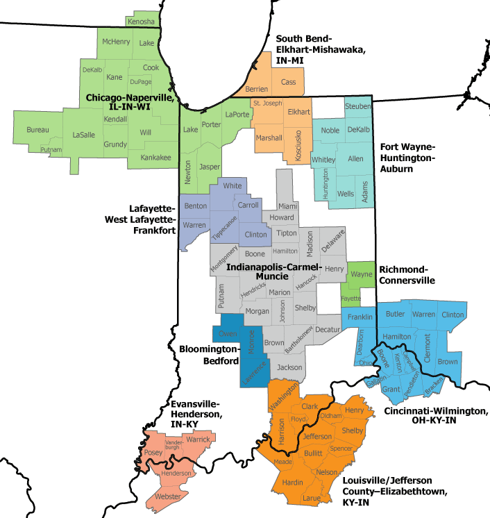
By definition, metropolitan statistical areas “have at least one urban area of 50,000 or more population, plus adjacent territory that has a high degree of social and economic integration with the core as measured by commuting ties.”7 Indiana still has 12 metros where the principal city is in Indiana, plus three additional metros where the principal city is in a neighboring state (see Figure 1).
Figure 1: Indiana’s metropolitan statistical areas, 2023
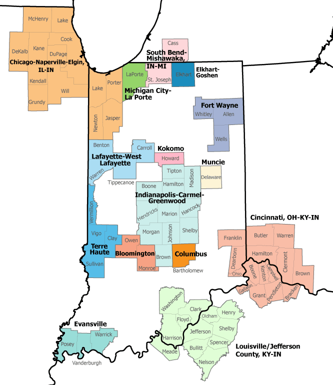
Source: Indiana Business Research Center, using July 2023 definitions from the OMB
Key changes in the 2023 delineations include the following:
- The Indianapolis metro has multiple changes. First, from a geography perspective, Tipton County has been added to the definition and Putnam County has been removed (the latter is now the Greencastle Micropolitan Area). Second, Greenwood has replaced Anderson as one of the principal cities in the region. Thus, what was formerly officially known as the Indianapolis-Carmel-Anderson metro will now be called the Indianapolis-Carmel-Greenwood metro.
- The Fort Wayne metro once again includes Wells County. Wells County has traditionally been part of the Fort Wayne metro area (from 1973-1983, and then again from 1992 to April 2018). When the OMB released the second set of 2018 delineations in September of that year, Wells County was omitted completely. Then, in the March 2020 delineations, Wells County was back as a statistical area, but this time as the separate (but short-lived) Bluffton Micropolitan Area.
- The Evansville metro no longer includes Henderson County, Kentucky. This represents a continuing shrinkage of the metro geography, as the Evansville metro also lost Gibson County, Indiana, and Webster County, Kentucky in the 2013 delineations.8
- The Terre Haute metro no longer includes Parke County.
- The Cincinnati metro no longer includes Union County.
Micropolitan statistical areas
Micropolitan statistical areas (micros) are similar to metros in definition, but differ in the size of the urban core: For micros, the urban area must have at least 10,000 people but less than 50,000 people. Indiana has 25 micros in the 2023 delineations (see Figure 2).
Figure 2: Indiana’s micropolitan statistical areas, 2023
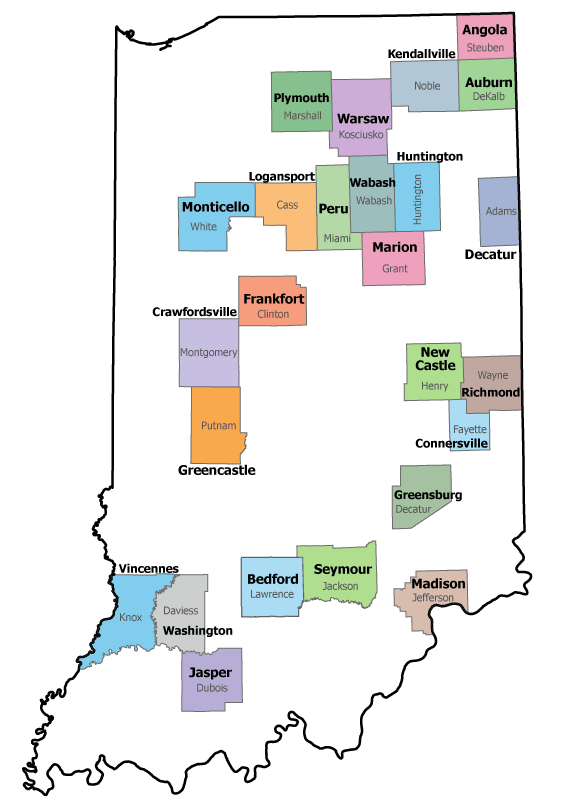
Source: Indiana Business Research Center, using July 2023 definitions from the OMB
Indiana gained two new micros in the 2023 delineations:
- Greencastle (made up of Putnam County—which was formerly part of the Indianapolis metro definition)
- Monticello (made up of White County)
However, three Indiana micros no longer exist:
- North Vernon (Jennings County)
- Bluffton (Wells County—which is once again part of the Fort Wayne metro). As mentioned in the earlier discussion of Fort Wayne, the Bluffton micro only existed in the March 2020 delineations, so it had a brief lifespan as a stand-alone micro.
- Scottsburg (Scott County)—Scott County has experienced multiple changes to its statistical area status through the years. Added to the Louisville metro in 1992, it was removed from the metro in 2003 to became the Scottsburg micro. With the 2013 delineations, it returned to being part of the Louisville metro (instead of a micro) through the April 2018 definitions. When the September 2018 delineations came out, it once again switched to the Scottsburg micro. But now, as of the 2023 delineations, Scott County is not included as part of any metro or micro region.
In addition, the Jasper micro no longer includes Pike County, but now solely consists of Dubois County. With that change, all of Indiana’s micro areas are single-county regions.
Metropolitan division
Metropolitan divisions are smaller groupings of counties within a larger metro area (i.e., one with a single core of at least 2.5 million people). The four counties in northwest Indiana still comprise the state’s only metropolitan division. However, in the 2023 delineation, the name has changed from the “Gary, IN Division” to the more verbose “Lake County-Porter County-Jasper County, IN Division” (see Figure 3).
Figure 3: Chicago’s metropolitan divisions, 2023
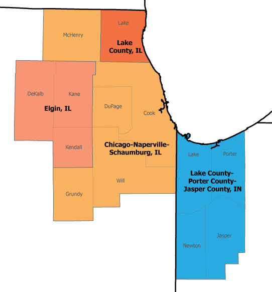
Source: Indiana Business Research Center, using July 2023 definitions from the OMB
Combined statistical areas
Combined statistical areas (CSAs) are combinations of adjacent metropolitan and/or micropolitan areas that have social and economic ties as measured by commuting—just at lower levels than the metros and micros themselves. They are “larger regions that reflect broader social and economic interactions, such as wholesaling, commodity distribution, and weekend recreation activities.”9
Indiana still has counties in 10 CSAs (see Figure 4), though we did exchange one CSA for a new one.
Figure 4: Indiana’s combined statistical areas, 2023
Source: Indiana Business Research Center, using July 2023 definitions from the OMB
Key changes to the Indiana counties in the 2023 CSA delineations include the following:
- Evansville-Henderson is a new CSA, which includes Henderson and Webster counties in Kentucky in addition to the Indiana counties in the metro.
- Kokomo-Peru is no longer a stand-alone CSA, but is now part of the Indianapolis-Carmel-Muncie CSA.
- The Lafayette-West Lafayette-Frankfort CSA now includes White County.
- The Indianapolis-Carmel-Muncie CSA no longer includes Decatur County, but it does now include Tipton, Howard and Miami counties (part of which was the former Kokomo-Peru CSA that no longer exists).
- Since the Cincinnati metro no longer includes Union County, it is by extension no longer part of the CSA as well.
When do these new definitions go into effect?
It takes time for the nation’s statistical agencies to deploy geography revisions into their data collection programs and the timelines aren’t coordinated across agencies. We provided an example of this in the introductory caveat that discussed how the U.S. Census Bureau’s ACS was using the 2020 delineations, while the U.S. Bureau of Labor Statistics’ QCEW program still relied on the 2013 delineations.
The QCEW program plans to deploy the new 2023 delineations with their data for 2024,10 but at the time of this writing, we do not yet have specific implementation timelines for the ACS and LAUS data programs. STATS Indiana and Hoosiers by the Numbers follow the BLS implementation schedule based on LAUS releases.11
In conclusion, while it is always important to understand the geographic extent of your region, it is especially critical to be aware of which counties are considered part of the statistical area you are gathering data for during this season of transition.Learn more
For a complete list of the nation’s metros, micros and CSAs, see Revised Delineations of Metropolitan Statistical Areas, Micropolitan Statistical Areas, and Combined Statistical Areas, and Guidance on Uses of the Delineations of These Areas, July 2023 from the OMB.
For nationwide Excel files, see Delineation Files from the U.S. Census Bureau.
Notes
- The U.S. Census Bureau actually defined metropolitan districts as early as the 1910 census, but these were based on minor civil divisions, not counties, prior to 1950. See “History: Metropolitan areas,” U.S. Census Bureau, https://www.census.gov/history/www/programs/geography/metropolitan_areas.html
- The Indiana counties included as part of a metro area in 1950 were Allen, Clark, Delaware, Floyd, Lake, Marion, St. Joseph, Vanderburgh and Vigo. See the U.S. Census Bureau’s “Metro Area History from 1950 to 2020” spreadsheet at https://www.census.gov/geographies/reference-files/time-series/demo/metro-micro/historical-delineation-files.html.
- Carol O. Rogers, “Narrowing the focus: How the federal government plans to define metropolitan areas in the 2020s,” InContext, March-April 2021, https://www.incontext.indiana.edu/2021/mar-apr/article1.asp
- “Geography boundaries by year,” U.S. Census Bureau, last modified August 16, 2023, https://www.census.gov/programs-surveys/acs/geography-acs/geography-boundaries-by-year.2022.html
- “Local Area Unemployment Statistics: Federal statistical area delineations,” U.S. Bureau of Labor Statistics, last modified March 15, 2019, https://www.bls.gov/lau/lausmsa.htm
- See question 21 at “Quarterly Census of Employment and Wages: Questions and answers,” U.S. Bureau of Labor Statistics, last modified September 15, 2023, https://www.bls.gov/cew/questions-and-answers.htm
- Office of Management and Budget, “Revised delineations of metropolitan statistical areas, micropolitan statistical areas, and combined statistical areas, and guidance on uses of the delineations of these areas, July 2023,” OMB Bulletin 23-01, https://www.whitehouse.gov/wp-content/uploads/2023/07/OMB-Bulletin-23-01.pdf
- Carol O. Rogers, “Gibson is gone (and so is Webster),” InContext, July-August 2013, https://www.incontext.indiana.edu/2013/july-aug/article5.asp
- See note 7.
- See note 6.
- “About the statistical areas,” STATS Indiana, https://www.stats.indiana.edu/about/metros.asp