The Compactness of Indiana's New Legislative Districts
On May 10, 2011, the state's new legislative districts were signed into law. Compactness scores are a frequently used means to evaluate the appropriateness of district boundaries. The general thinking is that one is less likely to encounter gerrymandering if districts are compact. Since there is no one standard or ideal measure of compactness, this article analyzes four of the most common compactness measures and looks at how Indiana's districts stack up.
Compactness Measures
Compactness measures can be divided into two types: dispersion (measuring how far a district spreads out from its center) and indentation (measuring how smooth the boundaries are). In all cases, high scores indicate the most compact areas and low scores indicate the least compact areas.
Dispersion Measures
- Reock: This method is quite simplistic: it is the ratio of the district's area to the area of the minimum spanning circle that can enclose it. Therefore, it consistently rates long, thin districts as the least compact.1
- Convex Hull: This method calculates the ratio between the district's area to the area of the minimum convex bounding polygon that can enclose it (that polygon is often described as what one would get if wrapping a rubber band around the district). It "is essentially capturing the extent to which the boundaries of the district bypass some geographical areas to capture others."2 Note: the convex hull areas were clipped to the state boundary so as not to artificially lower the scores for border districts.
Indentation Measures
- Polsby-Popper: This method looks at the ratio of the district's area to the area of a circle with the same perimeter. For both this method and the following Schwartzberg method, "detailed coastal boundaries are likely to be assigned low compactness scores, even if the overall shape of the district is reasonably compact" due to the emphasis on the perimeter instead of the overall shape.3
- Schwartzberg: This method is the ratio of the district's perimeter to the perimeter of a circle with the same area. (These scores were inverted for the sake of consistency with the other methods so that 100 is the most compact).
Results
Figure 1 shows the new congressional districts alongside the former ones. By and large, the congressional districts now follow county boundaries, with the exception of nine counties which are split into different districts (LaPorte, Kosciusko, Blackford, Morgan, Howard, Boone, Marion, Scott and Crawford).
Figure 1: Congressional Districts, 2001 and 2011
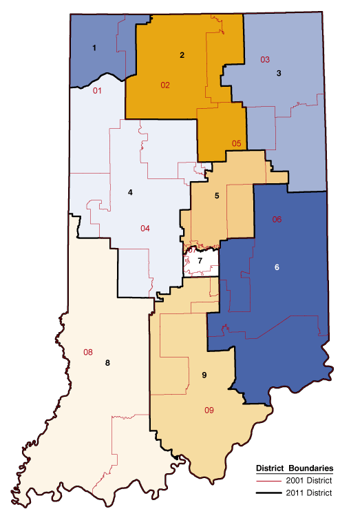
Source: IBRC, using Indiana Legislative Services Agency and U.S. Census Bureau data
Table 1 compares the compactness scores of Indiana's prior congressional districts with the newly created districts, showing that the new districts are more compact on average. While District 4 was the least compact district in the former system, District 8 now ranks lowest in the current system on three of the four measures. However, its scores are negatively impacted more by the jagged state boundaries rather than intentionally drawn boundaries.
Table 1: Compactness Score Comparison for Indiana's New and Former Congressional Districts, 2001 and 2011
| Name | Reock | Convex Hull | Polsby-Popper | Schwartzberg | ||||
|---|---|---|---|---|---|---|---|---|
| New Districts | Old Districts | New Districts | Old Districts | New Districts | Old Districts | New Districts | Old Districts | |
| District 1 | 47.0 | 35.3 | 87.7 | 93.1 | 57.9 | 49.4 | 76.1 | 70.3 |
| District 2 | 57.8 | 46.6 | 82.6 | 79.9 | 46.9 | 33.4 | 68.5 | 57.8 |
| District 3 | 44.9 | 64.2 | 89.8 | 93 | 51.7 | 52 | 71.9 | 72.1 |
| District 4 | 47.2 | 20.7 | 81.8 | 56.5 | 42.4 | 15.7 | 65.1 | 39.6 |
| District 5 | 44.1 | 29.8 | 77.6 | 66.4 | 34.8 | 16.4 | 59.0 | 40.6 |
| District 6 | 48.9 | 31.4 | 89.7 | 73.5 | 46.7 | 23 | 68.4 | 47.9 |
| District 7 | 61.5 | 53.6 | 93.5 | 78.4 | 51.2 | 18.4 | 71.6 | 42.9 |
| District 8 | 32.4 | 24.6 | 85.5 | 86.9 | 21.0 | 18.8 | 45.9 | 43.4 |
| District 9 | 42.4 | 33 | 82.4 | 79.8 | 35.7 | 22 | 59.8 | 46.9 |
| Average | 47.4 | 37.7 | 85.6 | 78.6 | 43.2 | 27.7 | 65.1 | 51.3 |
Bold indicates highest (most compact) value; red indicates lowest (least compact) value.
Source: IBRC, using Indiana Legislative Services Agency and U.S. Census Bureau data
Figure 2 and Figure 3 show how Indiana's General Assembly districts have changed.
Figure 2: Senate Districts, 2001 and 2011
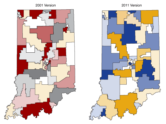
Source: IBRC, using Indiana Legislative Services Agency and U.S. Census Bureau data
Figure 3: House Districts, 2001 and 2011
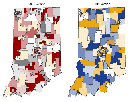
Source: IBRC, using Indiana Legislative Services Agency and U.S. Census Bureau data
The 100 house districts and the 50 senate districts are also more compact on average (see Table 2).
Table 2: Average Compactness Score Comparison for Indiana's New and Former General Assembly Districts, 2001 and 2011
| Name | Reock | Convex Hull | Polsby-Popper | Schwartzberg | ||||
|---|---|---|---|---|---|---|---|---|
| New Districts | Old Districts | New Districts | Old Districts | New Districts | Old Districts | New Districts | Old Districts | |
| Senate Average | 43.8 | 40.2 | 80.3 | 77.5 | 38.5 | 33.8 | 61.4 | 57.1 |
| House Average | 43.8 | 36.9 | 79.5 | 71.4 | 36.5 | 26.8 | 59.8 | 50.7 |
Source: IBRC, using Indiana Legislative Services Agency and U.S. Census Bureau data
Summary
Based on these four common compactness measures, Indiana's new districts are now more compact than in the past. To learn more about the new districts, view maps and access demographic profiles, visit the Redistricting topic page on STATS Indiana.
Notes
- Avencia Inc., "Redrawing the Map on Redistricting 2010: A National Study" (Avencia White Paper), 8.
- Ibid., 10.
- Ibid., 10.
Rachel Justis
Geodemographic Analyst, Indiana Business Research Center, Indiana University Kelley School of Business