How Will Indiana's Shifting Population Affect Legislative Redistricting?
With the election behind us, we now know that the Republicans will be in charge of the next round of legislative redistricting. Every 10 years congressional and legislative districts are redrawn, and Indiana’s General Assembly is likely to consider a range of factors in determining where to draw the lines. By law, the districts must be of roughly equal population (also known as equinumerosity).1
While the official 2010 population counts used for redistricting won’t be available until early next year, the following analysis uses the 2009 township population estimates (the smallest level of geography for which Census Bureau estimates are available) to explore population shifts since the last census. This provides an early sense of which Indiana congressional districts might need to grow or shrink geographically to meet the equal population criteria.
How Many People in a District?
When districts were last drawn in 2001, Indiana had almost 6.1 million people, so each of Indiana’s nine congressional districts represented approximately 675,609 people (give or take 160 people).2 As of the 2009 estimates, Indiana’s population has grown to more than 6.4 million. Indiana is not expected to lose a congressional seat, so we can estimate that each of the nine districts will contain about 714,000 residents (again, remember that this is an estimate based on 2009 data, not the official redistricting data which won’t be released until February or March 2011).
A Look at Township Population Shifts
Figure 1 shows change in township population between Census 2000 and the 2009 population estimates alongside the congressional district boundaries.
Figure 1: Change in Township Population with Congressional Districts, 2000 to 2009
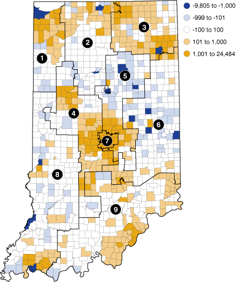
Source: IBRC, using U.S. Census Bureau data
The first step is to aggregate these township data to congressional districts. In cases where a township crosses multiple districts, the population was split based on the percentage of land area in each district (i.e., if 38 percent of a township’s land area was in District 1, District 1 received 38 percent of that township’s population). This yielded results +/- 2 percent of the actual Census 2000 population in most cases. However, this method assigned a bit too much of the Indianapolis population to Districts 4 and 5 instead of District 7.3
As a whole, Indiana’s population grew 5.6 percent between 2000 and 2009, but Table 1 shows that estimated growth rates varied dramatically among the various congressional districts. District 6 was the only district to actually lose population (-0.5 percent). Districts 2 and 8 both had growth rates less than 1 percent. On the other hand, Districts 4 and 5 each grew more than 14 percent (though bear in mind that some of this growth occurred within the shared townships that are under-represented in District 7).
Table 1: Estimated Growth in Congressional District Population Based on Township Aggregations, 2000 to 2009
| Estimates Based on Township Aggregations | |||||
|---|---|---|---|---|---|
| Congressional District | Actual Census 2000 Population | 2000 | 2009 | Numeric Change | Percent Change |
| 1 | 675,562 | 675,649 | 701,678 | 26,029 | 3.9% |
| 2 | 675,766 | 666,938 | 672,450 | 5,512 | 0.8% |
| 3 | 675,457 | 680,771 | 723,907 | 43,137 | 6.3% |
| 4 | 675,617 | 704,828 | 804,201 | 99,374 | 14.1% |
| 5 | 675,577 | 701,885 | 814,046 | 112,162 | 16.0% |
| 6 | 675,669 | 686,750 | 683,417 | -3,334 | -0.5% |
| 7 | 675,674 | 620,636 | 638,113 | 17,476 | 2.8% |
| 8 | 675,564 | 675,738 | 681,599 | 5,861 | 0.9% |
| 9 | 675,599 | 667,325 | 703,702 | 36,377 | 5.5% |
Source: IBRC, using U.S. Census Bureau data
Summary
After Census 2000, Indiana lost its 10th congressional seat, which caused a rather dramatic realignment of congressional districts. The state is not projected to lose a seat this time, but population declines in east-central Indiana, slow growth in western and north-central Indiana, and the concentrated growth around the Indianapolis metro area will make some boundary adjustments necessary to satisfy the equinumerosity requirement so each Hoosier’s vote will count equally.
When the Census Bureau releases the official redistricting data (known as the P.L. 94-171 data file) sometime during February or March 2011, we’ll make those data available on STATS Indiana and update this analysis using the official block-level data. In the interim, learn more about this once-a-decade process at the new Redistricting topic page at www.stats.indiana.edu/topic/redistricting.asp.
Notes
- It wasn’t until 1964 that the Supreme Court codified the “one person, one vote” principle, which requires that districts be of equal population. The Wesberry v. Sanders decision that year applied equal population requirements to congressional districts, while the Reynolds v. Sims case applied it to state legislatures.
- Congressional District 2 had the highest Census 2000 total population at 675,766, while District 3 had the lowest at 675,457 residents.
- In those townships which cross into neighboring districts, the share of population living in the District 7 portion is higher relative to the portion of township land area in the district. Based on the township aggregations, the estimated population of District 7 was only 92 percent of its actual 2000 population, while Districts 4 and 5 were both 104 percent of their actual population.
Rachel Justis
Geodemographic Analyst, Indiana Business Research Center, Indiana University Kelley School of Business